When Rochester, New York was first settled by Americans in the late 18th century, it was the waterfalls along the Genesee River that spurred the city’s settlement and growth. Today, the uppermost of these waterfalls, High Falls, can still be found in the heart of the city, but Lower Falls is located in a bit more isolated area.
Lower Falls can be found in the northern reaches of Rochester and is the last of the five major waterfalls on the Genesee River before its confluence with Lake Ontario (Three of which can be found in Letchworth State Park about an hour south of the city).
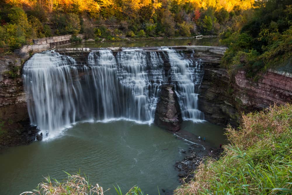
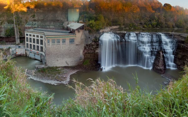
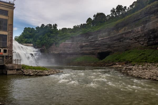
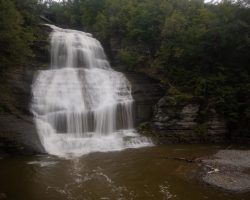
At 110 feet in height, this is also the tallest waterfall on the Genesee River, beating out Middle Falls in Letchworth State Park by three feet.
Unfortunately, because of this waterfall’s location deep in a gorge, it is the hardest of the waterfalls on the Genesee to get a good look at, but there are several great options for those wanting a look at this massive and beautiful waterfall.
Without a doubt, if you are looking for things to do in Rochester, NY, take a few minutes to check out this beautiful waterfall.
Where is Lower Falls in Rochester, New York?
Lower Falls is located 1.5 miles downstream of Upper Falls. Note that the Genesee River flows in a northerly direction starting in Pennsylvania and going through Letchworth State Park and Rochester before ending in Lake Ontario. All this means that you’ll need to head to northern Rochester to see this waterfall.
Lower Falls can be found at the following coordinates: 43.179378, -77.627761.
However, since you can’t park there or even see the waterfall at that specific spot, the exact location isn’t overly helpful. (I just provided it for reference).
For those that want to see the waterfall, there are several different spots you can view it from.
[Click here for information on how to use the coordinates in this article to find your destination.]
Driving Park Avenue Bridge
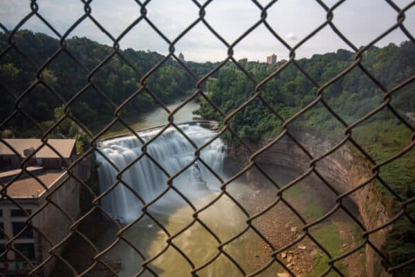
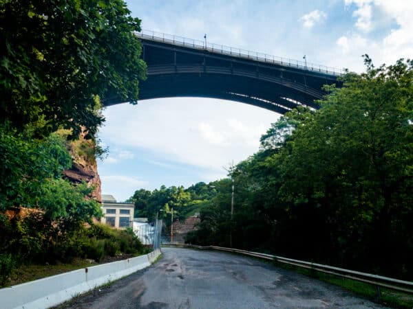
The quickest, easiest, possibly the best view of Lower Falls can be found along the southern sidewalk of the Driving Park Avenue Bridge.
This bridge stands at least 150 feet over the river and offers great head-on views of Lower Falls in Rochester.
While you can get a glimpse of the waterfall while driving over the bridge (stay in the right lane as you cross the river from west to east), your best bet is to park your car and walk to this viewpoint.
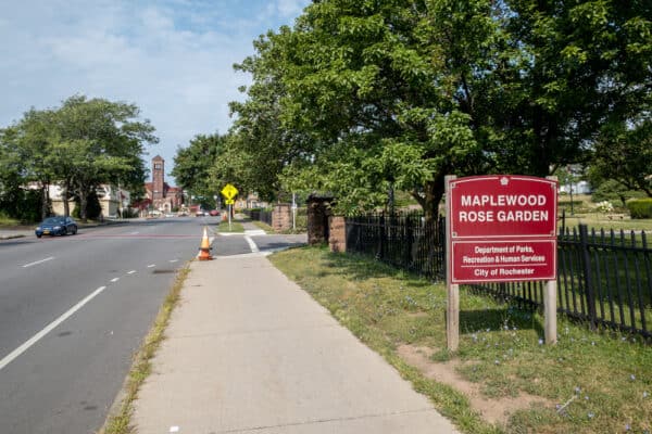
The closest parking area is located at Maplewood Park (which is also the jumping-off point for two other viewing areas listed below). This parking area can be found at the following coordinates: 43.181101, -77.630384.

If you’d rather use an address, use the Maplewood YMCA directly across the road from the park: 25 Driving Park Ave, Rochester, NY 14613.
From this parking area at Maplewood Park, cross Driving Park Avenue, and turn left to head towards the bridge. From the sidewalk here, you’ll have great views of the waterfall a roughly 250-yard flat walk from your vehicle.
While the views from the bridge are great, note that it is blocked a bit by the chainlink fence that has been erected across the bridge and is at a bit of a distance.
Lower Falls Park
Lower Falls Park is a second viewing area that you can access from Maplewood Park (coordinates: 43.181101, -77.630384).
To reach this viewing area, once again, cross Driving Park Avenue from the parking lot. However, instead of heading onto the bridge, follow the Genesee Riverway Trail away from the road and upstream towards the waterfall.
Unfortunately, while there are some really nice views of the waterfall here, they are all obstructed by the foliage and the rim of the gorge. So, without leaving the trail (which I highly encourage you not to do as it’s very unsafe), you’ll have obstructed views from this area.
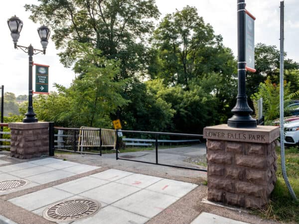
Fortunately, there are several viewing areas here that provide good, if obstructed views of the waterfall. There are also several signs that offer a bit of information about the site.
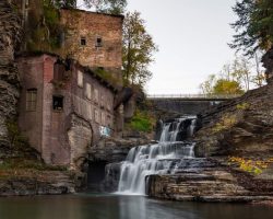
Furthermore, if you continue a short distance past the viewing areas for Lower Falls, you can also view the dam that sits where Middle Falls was once located.
DEC Fishing Access Site
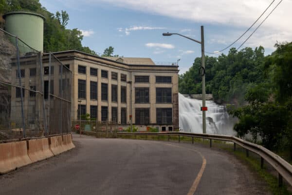
If you want to get near the base of Lower Falls, the only safe way to do so (and possibly the only legal way) is via a fishing access area on the eastern side of the gorge.
The parking area for this access area can be found along Seth Green Drive at the following coordinates: 43.187382, -77.623100. (You can also use this address, which will get you close, but not exactly to the park: 93 Seth Green Dr, Rochester, NY 14621).
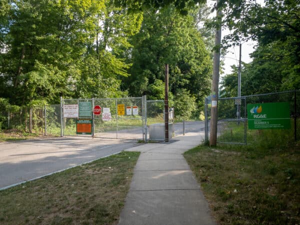
From this parking area, head towards the fence. This is a fishing access area, so visitors are allowed to hike past the fence. This walk is on a road that descends into the gorge and ends at the power plant.
All told, this is a half-mile one-way walk along the road. While this road is very lightly trafficked, as it is closed to the public, make sure to pay attention for any vehicles that might be driving on it.
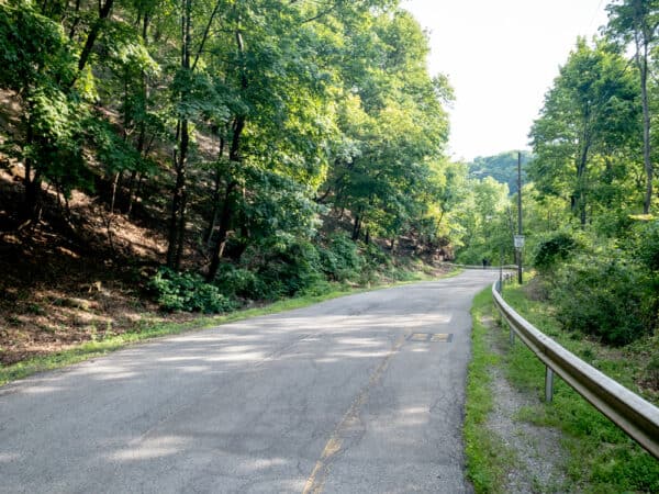
The hike down is relatively easy, though there is a gradual descent down into the gorge. While the walk down is fairly uninteresting, I did love staring up at the massive Driving Park Avenue Bridge high above the gorge.
As you near the power plant, there are nice views of Lower Falls, though, it’s hard to see the eastern side of the waterfall because of the large building. Nevertheless, this is a great viewing area for those that want to see Lower Falls from below.
It’s worth noting that there is a sign about 3/4 of the way down pointing to the river area for access. Ignore this sign and continue walking along the road to the power plant for the best views.
Note that there is a way to access the base of Lower Falls from Maplewood Park. However, given that this path is dangerous, off-trail, and of uncertain legality, I’ve opted to not include it here.
Looking for more things to do nearby? Check out the Charlotte-Genesee Lighthouse, the Seneca Park Zoo, and the best breweries in Rochester.

Thanks for this information. I have been looking for a way to view these fall.