Located in Columbia County, about 10 miles from the Massachusetts border is one of the most beautiful waterfalls in the Hudson Valley: High Falls.
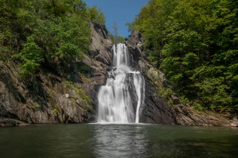
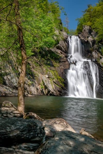
High Falls is located within the High Falls Conservation Area in Philmont, New York. At 150 feet in height, it is the tallest waterfall in Columbia County and one of the tallest and most impressive in eastern New York.
Since I always enjoy exploring the waterfalls of New York, I was excited to check out this great area.
There are a total of 1.5 miles of hiking trails within the High Falls Conservation Area. While the trails are neither long or especially difficult, they do provide a great chance to get out into nature and enjoy some beautiful scenery. There is also the opportunity for a bit of off-trail hiking to see a few of the best parts of the park.
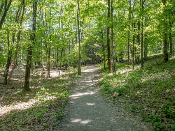
From the parking area, the green-blazed trail heads off into the woods. Soon, it passes a bench and crosses over a bridge before making a right turn. While the blue-blazed trail soon heads off to the left and the red-blazed trail to the right, stay on the green trail.
After about half a mile of walking, including one small hill, the green-blazed trail meets the red-blazed trail again. Keep going straight for another tenth of a mile.
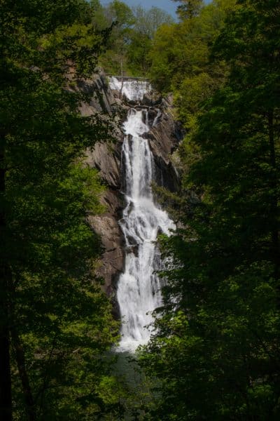
At the end of the red-blazed trail, you’ll come to the only official viewpoint for High Falls. From here, the 150-foot waterfall can be seen tumbling down the rocks. While this is a nice view at any time of the year, it can be a bit overgrown in the summer, so consider coming in the spring or the fall if you can (which will also give you better water flow typically, as well).
Adjacent to the waterfall and along the banks of the Agawamuck Creek, there used to be more than a dozen mills. While little evidence can be seen of most of them today, the dam at the top of the falls is still visible from this viewing area. This dam was built in the first half of the 19th century, so it’s quite old, but still seems to function as intended.
After taking a bit of time to enjoy this spot, you can head back the way you came or take the red trail to head back a different way to the parking area. However, I’d definitely recommend spending some time exploring the park a bit further.
Your best bet is to head down the green-blazed trail until you reach the blue-blazed trail heading off to your right and downhill toward the creek.
Follow the blue-blazed trail down to the Agawamuck Creek, and turn to walk upstream.
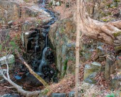
The Agawamuck Creek is incredibly beautiful as it cascades down the hillside. After about two-tenths of a mile, right at the end of the official trail, you’ll come to a large bonus waterfall in the park that I’d guess is around 40 feet tall.
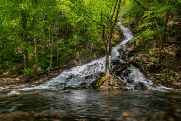
This stream seems to be unnamed and its existence isn’t shown on the park map, so I’d assume that it often doesn’t flow or has very limited flow. However, when it is flowing, it’s incredibly beautiful and is a great site all on its own.
If you aren’t comfortable with off-trail hiking and climbing over boulders, you should turn around now. On the other hand, if you don’t mind a bit of scrambling and possibly getting your feet wet, there’s an excellent view of High Falls to be had.
If you want to continue, go straight and follow Agawamuck Creek upstream for another tenth of a mile. There is no trail, and you will have to do some climbing up and over the boulders that line the creekbed, but the end of the trail features another great view of High Falls.
Keep in mind that this can be dangerous, especially if the rocks are wet and slippery, so use extreme caution if you opt to tackle this portion of the hike.
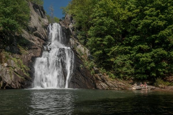
After a few minutes of scrambling, you’ll come to the base of High Falls. The waterfall sits on the opposite bank with a large pool of water separating you from the waterfall.
While it might look tempting, please don’t go for a swim here. Not only is the water on private property, but it is also quite dangerous and swimming is not allowed in the conservation area.
Once you’ve had a chance to fully enjoy the view of High Falls, make your way back to the green-blazed trail (again exercising extreme caution on the rocks).
While most people head back to their car at this point, there’s one more area of High Falls Conservation Area that is worth exploring.
Once back at the green-blazed trail, turn right as if you were heading back to your vehicle. However, when you reach the blue-blazed trail, take it down the hill again and back to the creek.
At the creek, you are going to want to walk downstream. There are a few user-created trails here, but nothing official, so make your way along the route that seems best.
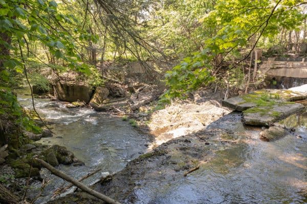
Soon, you’ll come to a small stream crossing (which you may or may not be able to cross without getting your feet wet). Just after that, you’ll come to an old dam on the Agawamuck Creek.
Be careful at this point as the dam and the rocky hillsides drop about 15-20 feet here, but across the stream, you’ll be able to see the remnants of an old mill. While it can only be observed from a distance as it sits on private property, it’s still very neat to see this historical ruin.
When you are ready to leave, trace your steps back to the green-blazed trail, and turn right to return to your car.
Overall, High Falls Conservation Area in Columbia County, New York, is a ton of fun to explore. Whether you just do the short hike to the official viewpoint of the falls or do a bit of off-trail hiking to see a few of this land’s hidden gems, this is a fantastic spot to visit in the Hudson Valley.
How to Get to High Falls Conservation Area
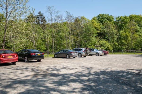
High Falls Conservation Area is located in Philmont, New York, in the northern reaches of the Hudson Valley. The parking area can be found at the following coordinates: 42.247240, -73.657729.
From here, it’s a little over half a mile to the main viewpoint for High Falls, meaning you can see the waterfall in a hike of just a bit over a mile.
On the other hand, if you want to explore the park and do the off-trail hiking as well, you are probably looking at around 2-2.5 miles of hiking.
For more information, visit the conservation area’s website.
Looking for more places to visit nearby? Check out Stuyvesant Falls, Cohoes Falls near Albany, Martin Van Buren National Historic Site, and Olana State Historic Site.
There is also a High Falls in Rochester, a High Falls Gorge in Lake Placid, and a High Falls near the Canadian border.
[Click here for information on how to use the coordinates in this article to find your destination.]