
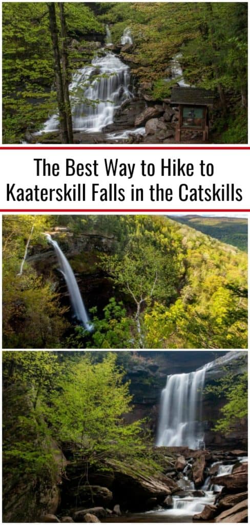

There many incredibly impressive waterfalls in New York, but few can compare with the beauty and grandeur of Kaaterskill Falls in the Catskills.
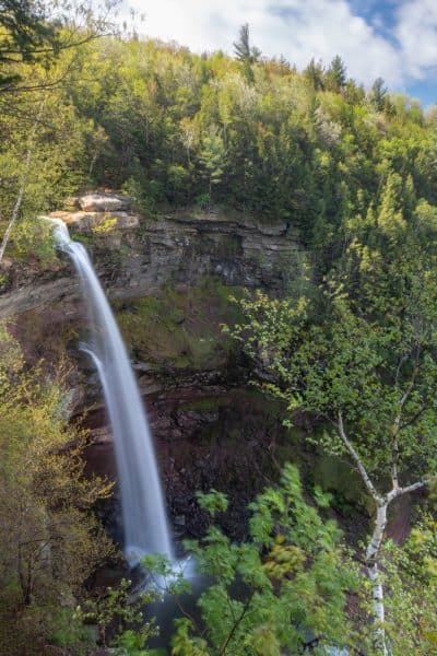
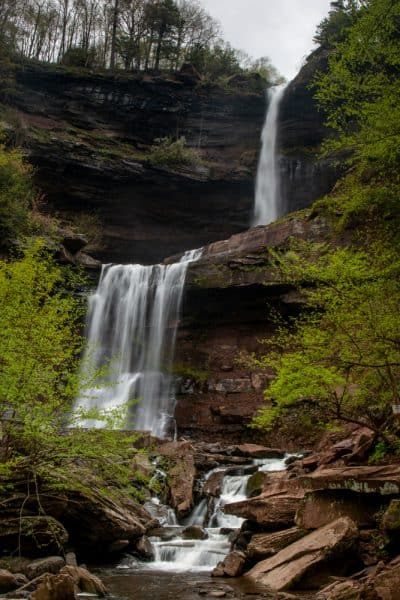
Kaaterskill Falls is 260 feet in height, making it one of the tallest waterfalls in New York. The upper drop is the larger of two at 175 feet, just a few feet shorter than the impressive Taughannock Falls in the Finger Lakes. The lower drop is a still-impressive 85 feet.
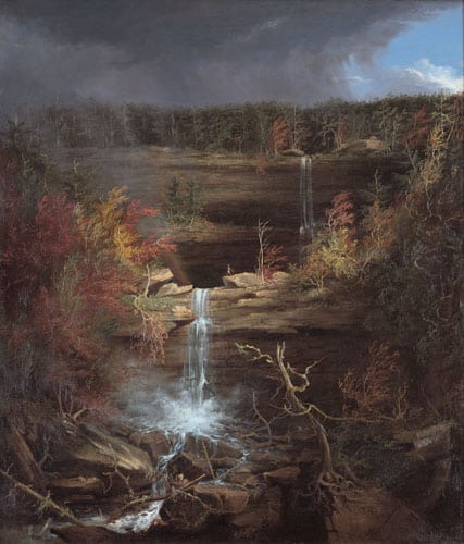
Kaaterskill Falls is one of the country’s oldest tourist attractions and has been depicted in many paintings, poems, and books since the 1800s. In fact, some of the most well-known paintings from Hudson River School artists such as Thomas Cole made this waterfall a central point in many of their paintings.
The falls can be accessed from both above and below, and while I’ll explain directions for both, I highly recommend starting at the top as this is both safer and easier. It also provides an overlook that can be reached by almost everyone and is listed as being handicapped accessible.
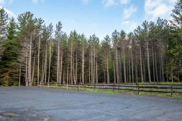
The top parking area was completed in 2016 and allows you to skip a very sketchy road walk that was once required to visit Kaaterskill Falls. Not only is this upper area safer, but it also makes the falls accessible to almost anyone and makes it easier for those wanting to explore the base of the waterfall as well.
The only disadvantage to parking at the top is that you miss Bastion Falls, an impressive waterfall that can be seen from Route 23A. But, more on that later because you definitely want to do this hike from the top.
The top parking lot is located near Haines Falls, New York, at the end of Laurel House Road (off of North Lake Road).
This parking area is much larger than the ones at the lower access areas and makes it obvious just how popular this spot is. Nevertheless, it also should mean you shouldn’t have any issues finding parking except at the busiest times.
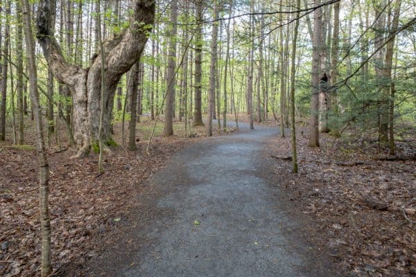
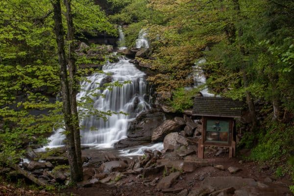
From the parking area, it’s an easy 0.3 miles to the upper viewing platform. Trails to the viewing platform are both wide and flat, and there are signs pointing the way to go. There are also signs near the vista that provide information on the waterfall and the history of the area.
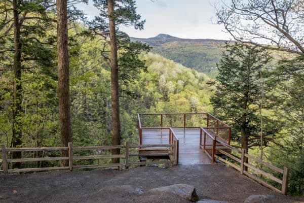
This upper viewing platform provides truly amazing views of the upper drop of Kaaterskill Falls, as well as the surrounding Catskill Mountains. The falls drop through a narrow opening in the treeline, and it feels almost magical standing in this spot and gazing out over the landscape.
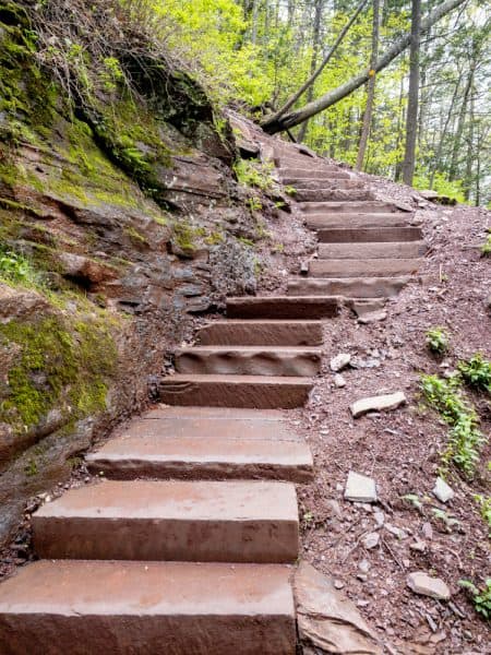
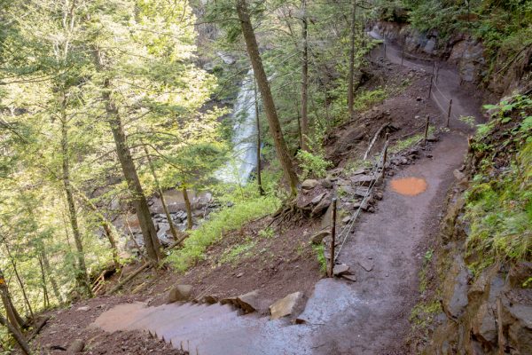
After taking a few minutes to enjoy this breathtaking view, it’s definitely worth the hike to descend to the bottom of the falls. Depending on your fitness level, this is a moderate to somewhat difficult hike, and the trail is made more challenging by various roots and rocks that line it.
The trail to Kaaterskill Falls remains relatively flat and easy for the first third of the hike to the base.
Following the signs from the upper viewing area, the trail passes through the woods and past an area where a hotel once stood decades ago. The trail then crosses a bridge over Spruce Creek a short distance upstream of the falls.
After crossing the bridge, the trail enters the woods and gets more difficult for the rest of the way to the base of the falls. From the point that you cross the bridge until you reach the base of the falls, it’s about a half-mile hike that features a 300-foot elevation loss.
Not a crazy elevation change, but enough to feel it if you are a bit out of shape like me.
The trail to the base makes one turn at a set of signs about a tenth of a mile into the woods and then winds through the woodland as it meanders its way towards the bottom of Kaaterskill Falls.
In spots, the footing is a bit tricky and the side of the hill somewhat steep, so make sure to take your time on the trail.
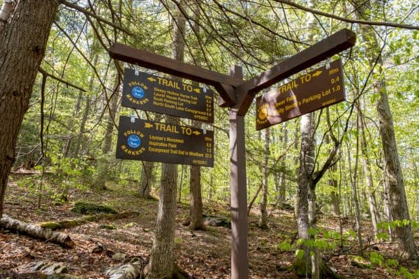
After about a third of a mile of downhill hiking, you’ll reach a junction in the trail. Heading down the hill will continue to take you towards the base of the falls. However, heading straight will take you to the middle level at the base of the upper drop.
If you opt to take this trail to the base of the upper falls, use extreme caution and stay away from the edge and out of the water here. While the falls can be quite majestic from this spot and staying on the trail should be safe, heading off-trail here has caused injuries and deaths in the past.
If water levels are high, there can be a tremendous amount of spray from the falls. This makes taking photos nearly impossible and it also makes the rocks here wet and slippery. I spent about 10 minutes trying to get a photo of the waterfall and was soaked from the spray off of the waterfall.
Once you’ve had your fill enjoying the upper drop of Kaaterskill Falls (safely from the trail), head back to the junction and continue downhill to the base of the falls.
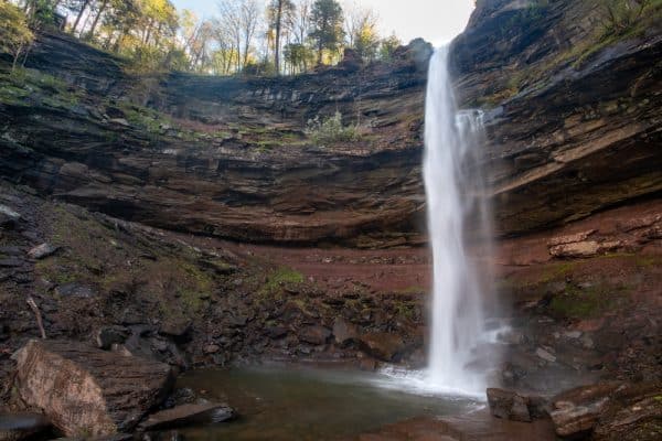
The large rocks at the base of Kaaterskill Falls provide the classic view of this waterfall that you most commonly see in photos and artwork. Of course, it’s not hard to see why as this is a truly majestic viewpoint.
This is an incredible spot to sit and relax and while taking in the beauty of Kaaterskill Falls. Unfortunately, though, you are unlikely to have this spot to yourself as nearly everyone that visits this falls also likes to spend a few minutes here.
Once you are done enjoying the falls, simply return the way you came for the 3/4-mile hike back to the parking area.
Parking Area for Kaaterskill Falls
While there are several places to park for the hike to Kaaterskill Falls, the best one is at the end of Laurel House Road. This road can be reached from Route 23A by turning onto North Lake Road in the community of Haines Falls in Greene County, New York.
This parking area can be found at the following coordinates: 42.195743, -74.063024.
While this parking lot is quite large, it can fill up early on beautiful weekends, so I recommend arriving early in the day if you must come on a weekend. Of course, the best time to come is early in the morning on a weekday, as I did, when you’ll see very few people at the falls.

Should the parking lot be full, do NOT park along Laurel House Road. This road is lined with dozens of “No Parking” signs and you are liable to get ticketed or towed.
Instead, return to North Lake Road, turn right, and head the short distance to another parking area at the following coordinates: 42.200744, -74.058449.
While the hike from this area is slightly longer, it does connect in with the trails from the first parking area and shouldn’t be much, if any harder.
For more information and a trail map of the trails around Kaaterskill Falls, check out the website for the Kaaterskill Wild Forest.
The Original Route to Kaaterskill Falls
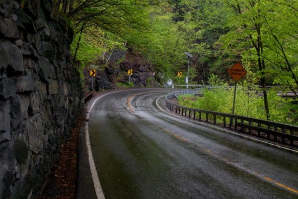
Up until the current parking area was completed in 2016, visiting Kaaterskill Falls was a much riskier endeavor. While I don’t recommend approaching Kaaterskill Falls from the bottom, it is the easiest way to see the 70-foot Bastion Falls at the base of the trail.
The old parking area for Kaaterskill Falls can be found at the following coordinates along Route 23A: 42.189907, -74.074039.
From this parking area, you’ll have to walk downhill along this very narrow roadway for a quarter-mile to reach the trailhead for the Kaaterskill Falls Trail. While cars typically are on the lookout for hikers, extreme caution is needed here if you opt to go this way as there is no sidewalk or shoulder for hikers.
At the trailhead for Kaaterskill Falls, the quite stunning Bastion Falls can be seen. This really is a great waterfall that gets overshadowed because it’s downstream of Kaaterskill Falls.
For those that want to see Bastion Falls without the dangerous road walking, it can be seen from the road, but sadly there is nowhere to stop for a closer look.
If you are hiking up to Kaaterskill Falls from Route 23A, the trail follows Spruce Creek uphill for about half a mile to the base of the falls. It’s worth the extra hike to climb all the way to the top to see the falls from the upper viewing area.
Looking for more places to visit nearby? Check out the abandoned Catskill Game Farm, Artist Falls, Awosting Falls, and the High Falls Conservation Area.
[Click here for information on how to use the coordinates in this article to find your destination.]


Thank you for sharing! This is amazing and informative. This website has really helped me discover New York State outside of NYC.
That’s great to hear! There are so many wonderful places to explore in New York state.
So helpful, thank you!
I love detailed information, so LOVE this! I appreciate the extra information as it will help with certain choices we make on how to explore these falls.
Because of the hazards to pedestrians, the state has closed the lower parking area on Rt. 23A.
Go for the autumn leaves! It is breathtaking!
Thank you very much. I am taking notes